Waseda Frontline Research Vol.18: Combating Unknown Threats and Hardware Trojans (Part 2 of 4)
Mon, Feb 5, 2018-
Tags
Nozomu Togawa, Professor, Faculty of Science and Engineering
Specialization: IoT, information and communications technology
Part 2: Maps that Let You “Feel” In Place
 As one of his research topics, Professor Nozomu Togawa of the School of Fundamental Science and Engineering is developing geographical information systems. He is attempting to apply several information and communications technologies to make the maps even more convenient. One example is a map information service that intuitively connects where we are in the real world with where we are on a map. (Interview date: September 7, 2017)
Map Information Processing Service
IoT is dramatically changing the way maps are used
In our laboratory, we are also studying maps and information processing services that use maps. Our research also targets technologies and products made possible with the Internet of Things (IoT), which was covered in Part 1.
Maps are essential tools which humans have used since ancient times. Think about the last time you used a map. When we look at a map, we compare our position on the map with our actual surroundings to determine where we are. In other words, we attempt to connect the real world in which we exist with the world depicted in the map. Some people have no trouble at all doing this. Others, however, get lost no matter how many times they consult a map. If we could connect the real world with maps more intuitively, information processing services that use maps would become even more convenient tools for more people. In our laboratory, we are currently working on research with several concrete products and services in mind.
Walking Route Information that is Easier to Understand
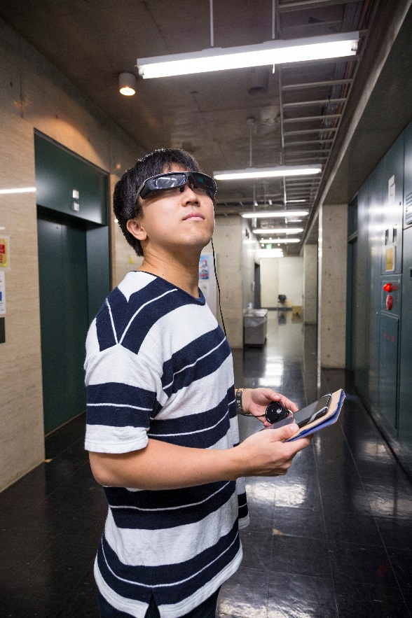
One example of this technology is a pedestrian navigation service that uses wearable devices called smartglasses.
One effective way of helping people to intuitively understand where they are on a map is to just show them their position on the map. You are probably very familiar with this if you have used a map application on a smartphone. You probably have also used a vehicle navigation system if you drive. One simple way for these map information provision services to indicate a user’s position on a map is to use a Global Positioning System (GPS). However, GPS does not always provide enough information for a user to determine where he or she is located. GPS technology has several limitations. For example, it cannot be used underground (where radio waves do not reach), and it only indicates position on a flat map. GPS information would not be able to tell you what floor you are on in a building.
In our laboratory, we are developing a system that uses wearable devices and augmented reality (AR) to guide users along a walking route to their destination. Our pedestrian navigation system uses smartglasses. As with GPS, it is crucial for our system to identify the user’s location. With that in mind, we thought of ways to further improve accuracy. One way was to use a technology called pedestrian-dead reckoning (PDR). PDR is a technology used to calculate and estimate the distance and direction a pedestrian has traveled by combining data detected from various sensors (including acceleration, inclination detection, and orientation detection sensors) installed in a terminal device.
PDR can be used to improve positional accuracy, based on the principle that a human will continue to walk straightforward without turning as long as he or she is presented with a straight road. We have installed various PDR sensors in smartglasses in our laboratory. Smartglasses present users with sensory images to guide them to their destinations. In an attempt to provide users with walking route information that is easier to understand, we use AR, which overlays virtual images over actual backgrounds.
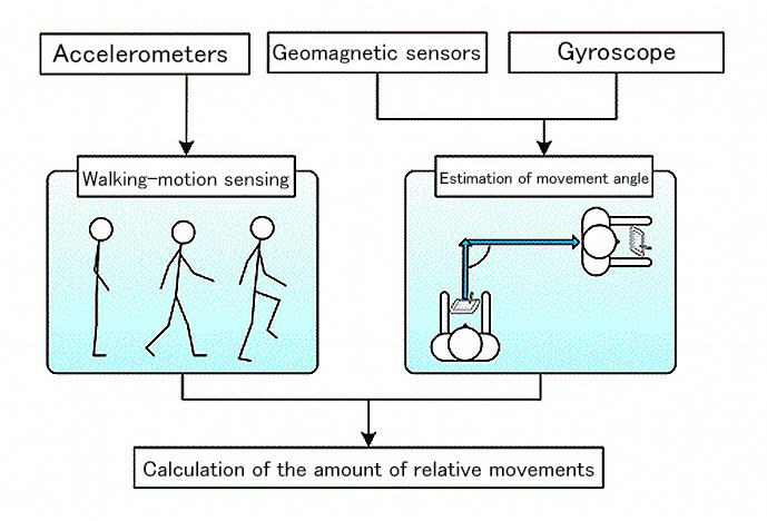
Figure: How pedestrian-dead reckoning (PDR) works. Sensors installed on the terminal device detect walking movement and estimate the movement angle in order to calculate the relative amount of movement (Source: Togawa Laboratory)
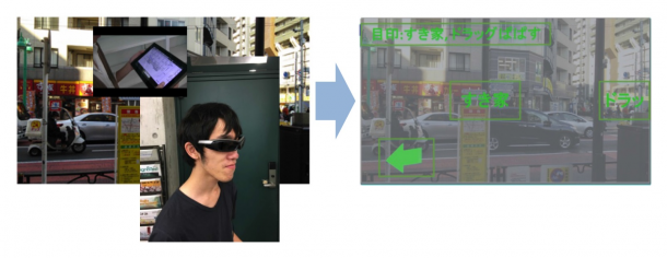
Figure: Concept image showing a pedestrian navigation system that uses AR. Wearable devices provide sensory information, such as information on buildings that could serve as landmarks or even arrows pointing the way to the user’s destination (Source: Togawa Laboratory)
Displaying Maps on Tiny Screens
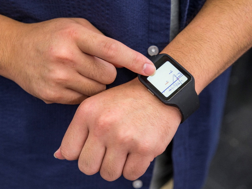
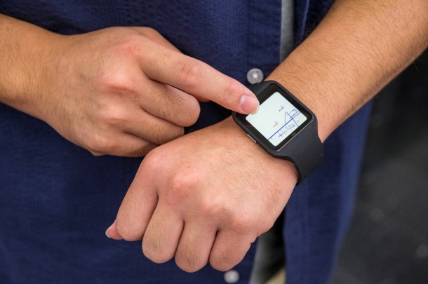
In our research to develop a geographical information processing service using wearable devices, we are attempting to use a technology called deformation map generation on wristwatch type wearable devices. As the name suggests, a wristwatch type wearable device is worn on the wrist. It offers excellent connectivity and the user does not need to take it out of his or her pocket to use it (as you would with a smartphone). However, the screens on these devices are smaller than those of smartphones. These devices therefore present us with the problem of how best to provide users with information on such a small screen. For example, if a digital map application is installed on a wearable device, displaying the names of all buildings shown could actually make it more difficult for the user to understand what he or she is looking at.
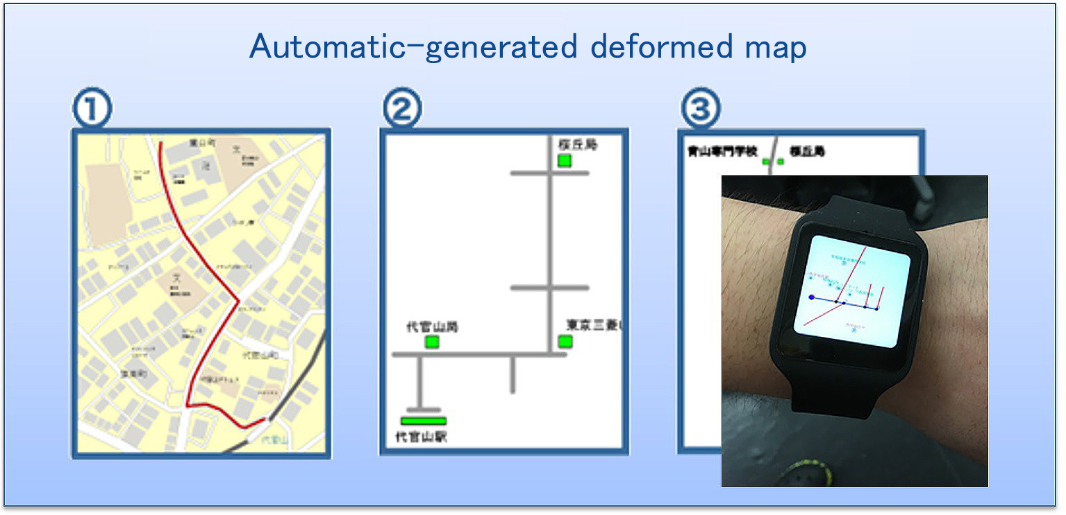
Figure: Concept image showing pedestrian navigation using augmented reality (AR) and deformation map generation. Simplifying maps by removing extraneous information improves convenience when using wristwatch type portable devices (Source: Togawa Laboratory)
How should we approach this problem? If we can select only certain information (such as buildings that could serve as landmarks) to be shown along the path to the user’s destination, the map would be much easier to read. Deformation map generation is a technology used to create simplified maps that only display the most useful information in order to make it easier for pedestrians to understand the route to their destinations.
Maps with a lot of information are not suitable for wristwatch type screens. However, users would likewise not feel comfortable with a map that was too simplified. A pedestrian walking along a 500 meter long straight road might wonder if he or she is on the right path after walking straight for a while. It is therefore important in deformation map generation to design maps that not only show information on buildings that could serve as landmarks for turning points, but also display information on other buildings so that the user can confirm that he or she is on the right path. We continue to stress usability as we study various methods.
Corporate Needs
As long as we are creating things and affiliated with the School of Fundamental Science and Engineering, I constantly make sure to engage in research that is socially significant. That is why my laboratory actively participates in joint research with companies. We are currently working with companies that provide navigation services and map utilization solutions for our research, such as the geographical information processing service I mentioned earlier. Companies provide information on current social needs, and universities produce seeds to meet these needs. This represents a basic form of a business-academia collaboration we pursue.
On the other hand, as a researcher, I am also engaged in research to create seeds of technologies that will be used by future society. 80% of my research now is conducted in collaboration with companies, while the remaining 20% involves exploratory research for future society.
In Part 3, Professor Togawa will discuss application system design to implement IoT.
☞Click here for Part 1
☞Click here for Part 3
☞Click here for Part 4
Profile
 Nozomu Togawa
Professor Togawa completed the Electrical Engineering Doctoral Course at the Waseda University Graduate School of Science and Engineering in 1997 (Doctor of Engineering). He has worked as a research associate in the School of Science and Engineering, Electronic/Information Communication Department, Waseda University; an assistant professor in the Faculty of Environmental Engineering, University of Kitakyushu; and an associate professor in the School of Fundamental Science and Engineering, Department of Computer Science and Engineering, Waseda University. Since 2009, he has worked as a professor in the Faculty of Science and Engineering (School of Fundamental Science and Engineering) at Waseda University. He specializes in integrated circuit design, and related applied technologies and security technologies. He has been the recipient of many awards, including The Telecommunications Advancement Foundation’s Telecom System Technology Award (2011). For details, visit the Togawa Laboratory
Major Achievements
Publications
- Hardware Trojans classification for gate-level netlists based on machine learning (2016 IEEE 22nd International Symposium on On-Line Testing and Robust System Design, 2016, p.203-206)
- A score-based classification method for identifying Hardware-Trojans at gate-level netlists (Design, Automation & Test in Europe Conference & Exhibition, 2015, p465-470)
- A Stayed Location Estimation Method for Sparse GPS Positioning Information (2017 IEEE 6th Global Conference on Consumer Electronics, 2017)
- An Accurate Indoor Positioning Algorithm using Particle Filter based on the Proximity of Bluetooth Beacons (2017 IEEE 6th Global Conference on Consumer Electronics, 2017)
Honors and Awards
1994 Student Paper Award, The Telecommuncations Advancement Foundation
1995 Best Paper Award, IEEE Asia and South Pacific Design Automation Conference
1995 Isao Okawa Memorial Achievement Award, Waseda University
1995 Azusa Ono Memorial Award, Waseda University
1996 Honorable Mention at the Circuit and Systems Workshop in Karuizawa, Nagano, JP, The Institute of Electronics, Information and Communication Engineers
1996 Ando Incentive Prize for the Study of Electronics, The Foundation of Ando Laboratory
1997 Yasujiro Niwa Outstanding Paper Award
2001 Takeda Techno-Entrepreneurship Award, The Takeda Foundation
2009 Honorable Mention from the Marubun Research Promotion Foundation
2009 Funai Academic Award, Funai Foundation for Information Technology
2010 Telecommunications System Technology Award, The Telecommunications Advancement Foundation